Laura and Lee and Walt and Barb's
Red Rock Reconnaissance
April 26-May 5, 2003
Part 2
Monday, April 28 - Canyonlands, Arches
Moab -> Canyonlands -> Arches -> Moab, 125 miles
Our breakfast was scheduled at 7:30, and we were awake and ready in
plenty of time. We met Vance, our other innkeeper, who was also the
chef. Oh wow...what a breakfast!!! Definitely NO excuse for going away
hungry! We had fruit and delicious oatmeal (amazing how good oatmeal gets
if you add enough sugar and nuts and fruit to it ;-) ) and some kind of
egg/potato
casserole, plus sausage AND pancakes! The pancakes were especially
awesome - big and thick but not heavy.
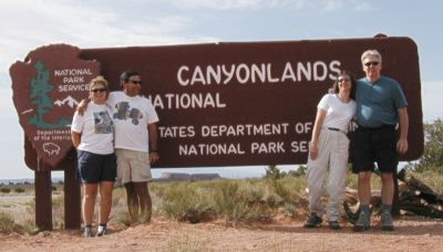 We mentioned to Vance that we were going over to Islands of the Sky in
Canyonlands Nat'l park,
and he recommended a hike to Upheaval Dome, and
also told us about an alternate driving route for the return trip- a
four wheel drive road, but he said we'd be fine with two wheel drive
since we'd be coming downhill. More on *that* later. :-) And he also
told us where to find some more Indian petroglyphs and dinosaur
tracks. Ahh...the advantages of staying with someone who has local
expertise!!!
We mentioned to Vance that we were going over to Islands of the Sky in
Canyonlands Nat'l park,
and he recommended a hike to Upheaval Dome, and
also told us about an alternate driving route for the return trip- a
four wheel drive road, but he said we'd be fine with two wheel drive
since we'd be coming downhill. More on *that* later. :-) And he also
told us where to find some more Indian petroglyphs and dinosaur
tracks. Ahh...the advantages of staying with someone who has local
expertise!!!
We were on the road about 8:30. Canyonlands was quite different from
what we were expecting - the area on the top was grasslands - but then
there were all these huge canyons in between. :-) There were very few
people there. We stopped at the Islands in the Sky
Visitor Center and then at several
viewpoints on our drive out to the Upheaval Dome trailhead. The
color on the canyon walls was amazing, though I think we all had the
same thought: "Who needs to see the Grand Canyon after seeing this?"
:-)
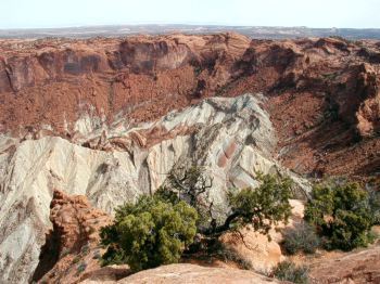 |
| Upheaval Dome |
The hike to the dome was about 2 miles round trip, a little steep in
places. The "dome" is really more like a big crater with a big
pile of colored sand in the middle, and there's two
schools of thought about its formation - some people think that it was
the site of a meteor crash, while others think it was a volcanic
crater. The different colors in the rock are very cool.
The hike reminded us of our hike to North Dome in Yosemite last year -
except that it wasn't as long and we were hiking on sandstone instead of
granite. :-) But it *was* uphill both ways and we had to walk on rock
surfaces that felt like the granite domes in Yosemite. The vegetation
and topography were very similar as well. So we aren't *completely*
crazy. :-)
Though we'd only seen one other couple on the trail on the way up, we
passed 10-12 people who were coming up the trail as we were going down.
Obviously it was a busy day at Canyonlands! :-) (That part was like
our North Dome hike, too - we didn't see very many people there,
either...quite different from the situation in Yosemite Valley!)
After we got in the Xterra and were driving back along with road, a
hiker on the road waved us down. He asked if we were going to the
Visitor Center (which was not our immediate destination, as we were
going to take the scenic drive to "Grand View" before heading out
of the park). But he told
us that his wife had fallen on the trail (a different and much more
difficult trail than we had done) and had at least a broken arm
and would probably have to be evacuated by helicopter, and could we
report it? Well, yeah!!! We got his information and Lee drove as fast
as he could to the Visitor Center (we had no cell phone coverage).
About the time we finished making our report the man showed
up, which surprised us because we thought he would wait back at the
trailhead until help arrived. At that point we'd done all we could, so
we left - it was about noon, and we still had to get back to Arches for
our ranger hike in the Fiery Furnace that afternoon. (We tried to find
out the next day if they'd gotten her out ok, but the woman at the
Arches Visitor Center hadn't been on duty the day before, and no one she
called to ask was at their desk. Since she didn't know about it, we assumed
that the situation must have been gotten resolved...we hope the lady was
ok.)
 |
| Xterra and rock |
We followed Vance's directions and found the road down Long Canyon with
no problem. It started out fine, but then it suddenly got pretty steep
and narrow...and a little sandy. With a steep drop off the side of the
road. Lee felt quite in control since he was driving, but his
passengers weren't quite as comfortable. :-) Then we came to
the place where there was this *very* large rock that had fallen
on the edge of the road and was leaning against the cliff wall,
creating a tunnel underneath. Lee looked at it and said "I can't
make it under that!" Which would have been bad, because at that
point I'm not sure we could have backed up the hill - it was pretty
steep and a little soft and sandy. But it was like it is with
parking garages - you look at it and think there's no way it's high
enough, when really there's plenty of clearance. (Besides, Vance had
told us that he'd done this road in *his* truck.) Once we got
through that we had a little MORE excitement - a Humvee coming *up*
the road. Fortunately we were at one of the few places where the
road had widened out - we pulled way over to the side of the hill
and let the Humvee pass us on the *outside*. :-)
It WAS a really scenic drive down, though - the canyon walls and rock
formations were beautiful. It was a little more challenging than we had
expected given Vance's description, though. But we resisted the urge to
leap out of the car and kiss the ground when we got to the bottom. :-)
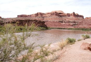
 At the bottom we came out near the
Colorado river...and looked at the
water that we are probably drinking in San Diego right about now.
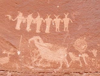
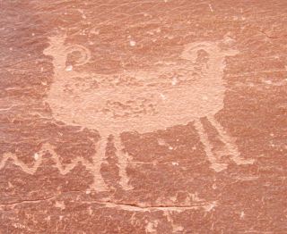
:-) Up the road we found the turnoff for the petroglyphs and
dinosaur tracks. We had a rock scramble to get up there, but it
was interesting to see them. I think the guy on the left side looks
like an alien with a ray gun!
And then there's the one that looks like Dr.
Doolittle's Pushmepullyu.
:-)
At the bottom we came out near the
Colorado river...and looked at the
water that we are probably drinking in San Diego right about now.
:-) Up the road we found the turnoff for the petroglyphs and
dinosaur tracks. We had a rock scramble to get up there, but it
was interesting to see them. I think the guy on the left side looks
like an alien with a ray gun!
And then there's the one that looks like Dr.
Doolittle's Pushmepullyu.
:-)
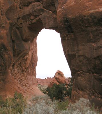
Back in Arches again we did the one mile hike called "Park Avenue",
which takes you down through an area of huge rock formations. Even an
arch or two. :-) Then it was time for our "Fiery Furnace" hike.
 |
| The Fiery Furnace |
We met the ranger at the trailhead - there were a total of 24 people in
our group. The "ranger" is actually a volunteer - we learned that there
are very few full-time rangers in the parks, and that most of the people
we saw staffing the Visitor Centers and Entrance Stations are
volunteers. But to have any chance of getting a job with the Park
Service you have to have a lot of hours as a volunteer first, and that's
what our "ranger", Robin, was trying to do.
Our hike started at 4:00 and ended at 7:00. It was only about two
miles, but there was some rock scrambling involved and that took time
with a large group, plus we stopped a lot so Robin could show us
various geologic features and talk about them. It was another windy
afternoon, and some of the areas we were in had a lot of blowing sand.
Robin told us more about cryptobiotic crust (we learned that
"cryptobiotic" means "hidden life") and the importance of staying off of
it. For most of our hike in the Fiery Furnace we were in sandy washes
or on rock.
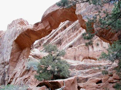
We learned about the peculiarities of the Entrada Sandstone that allow
it to produce so many spectacular arches (they have counted over 2200
in the 76,000 acre park). Entrada Sandstone has three layers - Moab
Tongue, the hard capstone; Slickrock, the porous sandstone; and the
Dewey Bridge, a more clay-like non-porous layer. Water goes through
the top two layers just fine, but when it gets to the Dewey Bridge it
suddenly is trapped and looks for a way to escape...which ends up
weakening the sandstone at the bottom of the slickrock layer allowing
wind and water to erode it away. In time, this erodes up and
eventually an arch is formed. There are three requirements for a hole
in the wall to be an arch: the hole must go all the way through the
wall, it must be at least 3 feet wide, and the erosion must be caused
by wind and precipitation rather than by the flow of water, e.g. a
river. (An "arch-like" structure created by a river is called a bridge
and not an arch.)
We also learned why Delicate Arch is able to stand on its own the way it
does rather than being in a wall like all the other arches we saw are -
it is actually topped by the very hard Moab Tongue capstone layer, which
is more resistent to erosion.
She also told us about "desert varnish" - the dark color that
appears on some sandstone cliffs. (You can see it on the top left in
the picture below.) It's what most petroglyphs are carved
into. Depending on who you talk to, it's either caused by rain, dust,
bacteria, and manganese, or it's a chemical reaction between rain,
dust, and manganese.
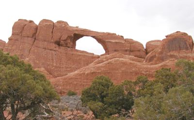
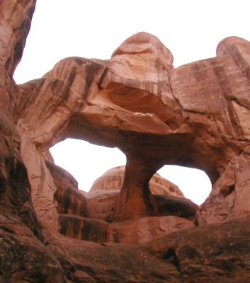 |
Arch of the Day
Skull Arch, Arches National Park |
Anyway...Fiery Furnace was full of all kinds of colorful rock formations,
narrow slot canyons, and of course arches. Like Crawl Arch, Surprise Arch, Kissing Turtle Arch, and
Skull Arch - which is today's "Arch of the
Day".
It was a terrific hike, and we learned a lot of stuff, plus it was a
treat to be able to go into an area where most people can't!
Back to Moab, where we had dinner at the Moab Brewery again. (Lunch had
been jerky and dried fruit and pita chips again.) We got some more
of those yummy onion rings and this time we had dessert there, too
- the chocolate mousse pie was ok, but Barb had the winner - the
Chocolate Spoon cake. Rich and chocolatey!
After we got back to the Inn we all took advantage of the hot tub - it felt
really good!
Tuesday, April 29 - Arches, Goblin Valley, Capitol Reef
Moab -> Arches -> Moab -> Goblin Valley -> Teasdale, 243 miles
Moving day! Vance prepared us another awesome breakfast - we had
yogurt/granola/fruit parfaits, another oatmeal serving, eggs, and bacon.
There was supposed to be coffeecake, but it wasn't done yet, so they
gave it to us before we left to eat later.
We packed the car and left about 9:00 and went back to Arches one last
time. Our first stop was Skyline
Arch. Unfortunately it was an overcast day and not very good for
pictures. And it was still windy - it was basically windy for the
entire trip.
We drove to the
Devil's Garden trailhead and
took off to see, guess
what, some more arches!!! :-) (This was at my request...I was
obssessed with arches. Of all the parks we visited on that trip when I was
8, Arches was the park I was most interested in seeing
again. And it did not disappoint me - if anything it was even more
spectacular than I remembered. Besides, I needed to find my Arch of
the Day!)
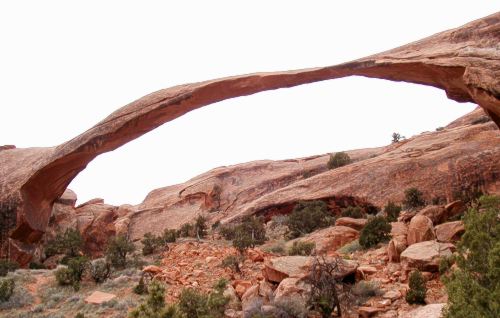
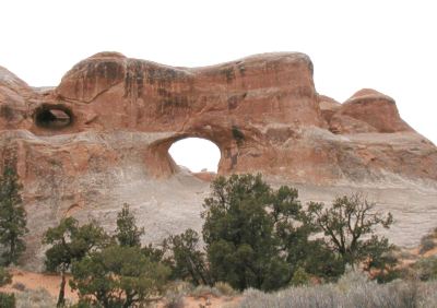
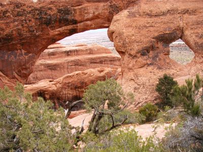
Arch of the Day
Landscape Arch, Arches National Park
We didn't have time to do the entire Devil's Garden trail, but we did
just over 3 miles of it in a little less than two hours. Landscape Arch
(today's Arch of the Day!) is over 300 feet long, and only about 11 feet
wide at its narrowest point. You can see fairly recent rockfall in the
picture below the arch - a large piece fell in 1991 and some smaller
pieces in 1995. Sure wish I'd had blue sky behind this rather than
gray!
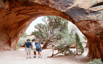
We also saw Tunnel Arch,
Pine Tree Arch,
Wall Arch (and doesn't it remind you of
the letter "M"?),
Navajo Arch, and
Partition Arch.
We drove back to Moab to have lunch and do some t-shirt shopping (gotta
get a souvenir!!!) and we were on the road to Capitol Reef National
Park at about
2:30. Though our first stop was:
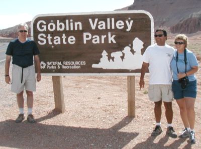
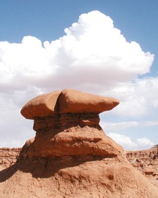
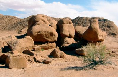
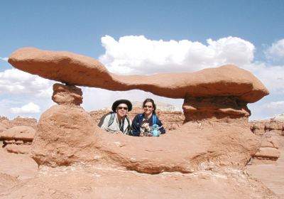
Goblin Valley
State Park.
 This is where the alien planet scenes from the movie Galaxy Quest were
filmed...it really does look like an alien landscape! It was still
very windy (poor Barb was having a terrible time with her contacts),
but we wandered around in the valley among the
goblins for about 45
minutes. Lee found a formation that looked like the defeated
rock monster from Galaxy Quest. :-)
This is where the alien planet scenes from the movie Galaxy Quest were
filmed...it really does look like an alien landscape! It was still
very windy (poor Barb was having a terrible time with her contacts),
but we wandered around in the valley among the
goblins for about 45
minutes. Lee found a formation that looked like the defeated
rock monster from Galaxy Quest. :-)
After
communing with the goblins
we continued our drive towards Capitol
Reef. Along the way we went through the town of Caineville. Something
weird was going on...it was a very small town, but we passed by a field
where there were lots of cars parked, and nearby was a hill with lots
of people standing on it. We were convinced that they were all pod
people, and made haste to get out of the area as quickly as possible.
:-) (From what I've learned since then, Caineville is a popular
motocross area, and my guess is that there was some kind of
competition going on though it seems strange that it would be happening
mid-week. But "pod people" make a better story. Especially since we'd
seen all those goblins earlier...maybe those are the pods! :-))
 It was 6:30 by the time we reached
Capitol Reef National Park. We
stopped along the road to take a few pictures, but the Visitor Center
was closed, so we continued through the park to the little town of
Teasdale, where we checked in at the
Muley Twist Inn. Our innkeepers
recommended Cafe Diablo in nearby
Torrey (and the Lonely Planet guide
said the same) so we went there for dinner. Oh my. You *don't* expect
a 4 star restaurant in a town with a population of less than 500, but
this place was amazing. The presentation of the food on the plates was
incredible, and it was delicious, too! The desserts were good,
too...each dessert also came with a scoop of homemade ice cream. It was
a terrific dinner, but boy, was it *cold* when we came out of the
restaurant! It had turned into a frosty night.
It was 6:30 by the time we reached
Capitol Reef National Park. We
stopped along the road to take a few pictures, but the Visitor Center
was closed, so we continued through the park to the little town of
Teasdale, where we checked in at the
Muley Twist Inn. Our innkeepers
recommended Cafe Diablo in nearby
Torrey (and the Lonely Planet guide
said the same) so we went there for dinner. Oh my. You *don't* expect
a 4 star restaurant in a town with a population of less than 500, but
this place was amazing. The presentation of the food on the plates was
incredible, and it was delicious, too! The desserts were good,
too...each dessert also came with a scoop of homemade ice cream. It was
a terrific dinner, but boy, was it *cold* when we came out of the
restaurant! It had turned into a frosty night.
Part 3
Back to Laura and Lee's Vacation Page
This page has been viewed
 times.
Text and photographs copyright © 2003 by Laura Gilbreath.
"Rock monster" photo copyright © 2003 by Lee Zimmerman, "Xterra
and Rock" photo copyright@copy; 2003 by Barbara Fletcher, used with
permission. All rights reserved.
Laura Gilbreath lgil@cts.com
Last updated 5/16/03